The West Midlands region in England is trialing a new fully automated drone service to identify and resolve transport issues faster. Public body Transport for West Midlands (TfWM) has joined forces with drone company SkyBound Rescuer to ensure an eye in the sky in the areas that don’t have CCTV coverage.
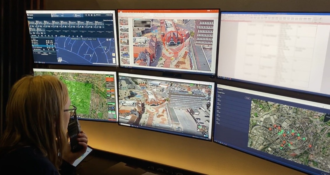
With more than 2,500 fixed CCTV cameras under its purview, TfWM monitors the bus, train, road, and tram network across the West Midlands region from a centralized control room. But when an incident occurs in an area that doesn’t have CCTV coverage, it can be difficult to track the situation or understand its complexities.
This could change now with the installation of an automated drone station in the market town of Walsall. This station is essentially a high-tech box that the drone sits in. It enables precise take-off and landing of the aircraft and recharges the drone without needing to remove the battery. The technology also creates an internet hotspot so that mission plans can be sent remotely. Put simply, it makes the drone fully self-sufficient.
SkyBound Rescuer has paired this tech with proprietary software where transport officials can send flight requests. A request form takes an average of 49 seconds to complete. And once it is sent to the system, the algorithms generate a mission plan optimized for safety and performance. While designing the flight path, the software further ensures that the drone remains within the visual line of sight from the onsite remote safety pilot and avoids intentional overflight of people.
This combination of hardware and software ensures the end-to-end flight is fully automated, and that the humans-in-the-loop can dedicate their attention to monitoring the flight and enhancing situational awareness from its imagery instead.
Also read: Drones monitor water levels for threatened bull trout in Washington
It’s also worth highlighting that SkyBound’s software enables every pixel in its video stream to be quickly located in the real world using its What3Words location. Meaning, you can click on an activity in the video, locate it, mark it on a map, label it, photograph it, and timestamp it within the recorded footage – all within a click of a button. So if the drone captures something that could be of an evidential nature, it can be stored and retained as is done for fixed CCTV footage.
As Gemma Alcock, founder and CEO of SkyBound Rescuer, explains, not only automated drone technology helps to mitigate transport issues before they impact communities (such as delays to public transport), but it can also enable officials to rapidly respond to live incidents like road traffic collisions. Alcock says:
Week one of the trial service was a huge success! On average, it took 5 minutes 44 seconds to respond to a flight request. To put that into context, the service level agreement for the National Police Air Service is to respond within 15 minutes to Priority 1 calls for service. Therefore, when a transport emergency occurs, such as a road traffic collision, SkyBound’s automated drones can respond almost 3x faster than the police helicopters.
Kerry Blakeman, head of security and policing of Transport for West Midlands, adds, “Eight months ago we set up our own dedicated in-house drone team to explore the benefits of drone technology. We’re delighted to be partnering with SkyBound Rescuer to explore the potential of automated drone technology which will revolutionize the CCTV industry.”
Read more: New firmware update for DJI Terra drone mapping software
FTC: We use income earning auto affiliate links. More.


Comments